HPC enabled local probabilistic tsunami hazard assessment workflow
Tsunamis pose a hazard to coastal communities and infrastructure in many parts of the world. They are relatively infrequent but can result in devastating human losses and enormous economic consequences. Most tsunamis are generated by large offshore earthquakes. The whole propagation process of a tsunami wave can be simulated, starting from the deformation of the sea floor to inundation on a coastline of interest, using high-resolution numerical models.
This service is part of the candidate Thematic Core Service for tsunami and will be integrated into the Integrated Core Service Data Portal of the European Plate Observing System (EPOS).
This is a collaboration between NGI, INGV, Universidad de Malaga (UMA), and CINECA.

Probabilistic Tsunami Hazard Analysis (or PTHA) estimates the probability of exceeding a specified metric of tsunami inundation at a given location and within a given time interval.
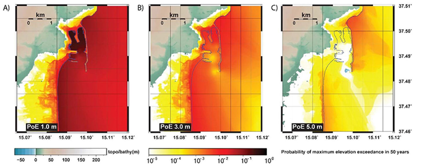
Probabilistic hazard maps, examples of which are displayed below (Figure 1), may be of importance for insurance evaluations, emergency planning (e.g., evacuation routes), coastal engineering (planning constraints), and civil protection (hazard zonation for emergency planning).

Figure 1: The probability of exceeding a flow depth of (A) 1 meter, (B) 3 meters, and (C) 5 meters in a time-interval of 50 years at the town of Catania on Sicily. The topobathymetric grid has a resolution of 10 meters.
PTHA requires many earthquake scenarios – potentially many hundreds of thousands – to account for all the possible sources contributing to the hazard at the location of interest. The concept is not new, but, until very recently, it could only exploit regional models and provide statistical estimates for the expected impact along a stretch of coastline.
High-resolution tsunami inundation simulations had also been performed in the past, but usually for very limited numbers of earthquake scenarios: typically hindcasting actual events or hypothetical worst-case scenario estimates.
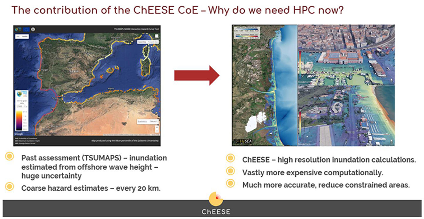
A local PTHA, with both high-resolution inundation simulations and the vast numbers of scenarios needed, has only become feasible with highly parallel calculations on vast supercomputers. We sketch how HPC has advanced the state of PTHA in Figure 2.

Figure 2: How High Performance Computing (HPC) is reshaping the capabilities for Probabilistic Tsunami Hazard Analysis. In the past, we would simulate the offshore tsunami wave and use statistical models to predict the severity of the inundation over a length of coastline. Inundation calculations, with far more complicated flows in shallow waters, modeled on high-resolution numerical grids, require longer and larger simulations. Recent advances in supercomputing have made it feasible to perform these demanding calculations for the vast number of earthquake scenarios needed.
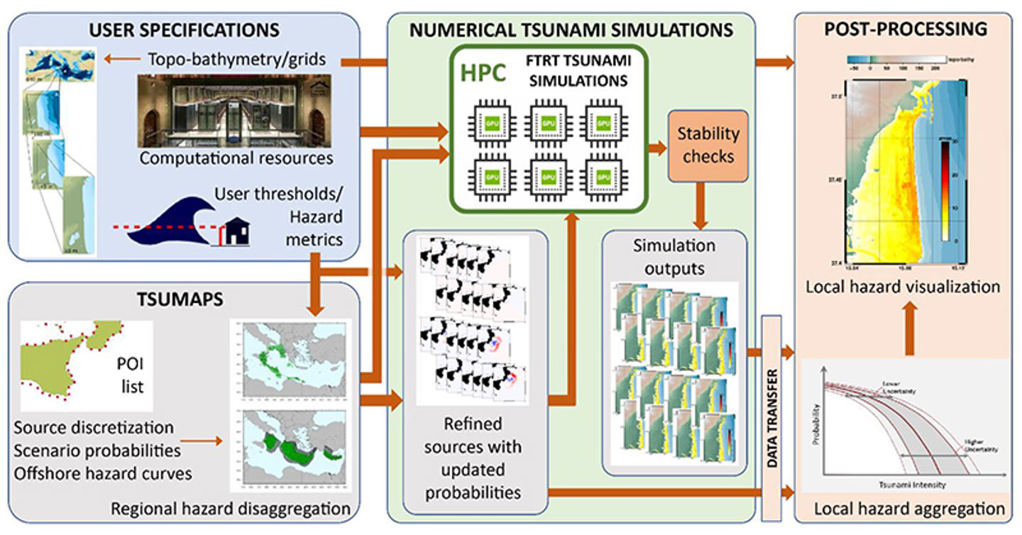
Under the ChEESE-project we have designed, implemented, tested, and applied a workflow for calculating local PTHA for Sicily. This workflow is a blueprint for providing services related to performing local PTHA for a coastline of interest.

Figure 3: A workflow for local Probabilistic Tsunami Hazard Analysis taking as input user-supplied topo-bathymetric grids and specified hazard metrics. The underlying earthquake models (including probability of occurrence) is the TSUMAPS1.1 model. The numerical tsunami simulations are carried out at external HPC centers, and the hazard results are summarized and visualized for the user.
See paper on TSUMAPS1.1 model.
The user would need to specify the following:
- bounds of the region where inundation quantification is required
- topobathymetric grids for the coastline of interest and tsunami source and propagation modeling
- return period of interest
although we would provide advice on all aspects of the specifications. The computational resources needed depend on the size of the simulations and the number of scenarios required. The Tsunami-HySEA code requires GPUs.
In all the tsunami simulations performed, we save sea level time series and inundation maps to train and develop Machine Learning components in workflows.
Link to the repository: https://doi.org/10.5281/zenodo.6376607
The method is described in the following open-access publications:
- Probabilistic Tsunami Hazard Analysis: High Performance Computing for Massive Scale Inundation Simulations, Frontiers in Earth Science 2020
- Testing Tsunami Inundation Maps for Evacuation Planning in Italy, Frontiers in Earth Science 2021
- The Making of the NEAM Tsunami Hazard Model 2018 (NEAMTHM18), Frontiers in Earth Science 2021
- The Computational Engine Used for the tsunami simulations is Tsunami-HySEA
